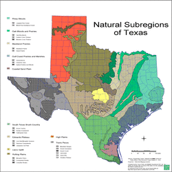
There are three sub-regions in the North Central Plains, each with different physical features: the Grand Prairie, the Cross Timbers, and the Rolling Plains.
The Grand Prairie is a flat, grassy area that stretches across the east and center. It is a long, narrow belt of land that goes from Killeen in the Coastal Plains to the Red River in the north. It is adapted for raising livestock and growing crops with few trees.
The Cross Timbers surround half of the Grand Prairie and are comprised of forests that contain many hardwood trees. This sub-region is divided into Eastern and Western Cross Timbers. The East extends from the Red River to Denton County near Dallas. The West is much larger, crossing from the Red River all the way down to the Llano Basin near the Colorado River.
The Rolling Plains is the largest sub-region. It covers over two-thirds of the North Central Plains. Grassy hills wave around this region. There is little rainfall in the Rolling Plains, only getting 20 to 30 inches of rain a year, but cattle and agricultural industries thrive there.
